Let me explain what an endoheric basin is. This is easy – and very important to your happiness in life. Let us, therefore, turn to the great arbiter of truth on the internet, Wikipedia, which says:
“An endorheic basin is a closed drainage basin that retains water and allows no outflow to other external bodies of water, such as rivers or oceans, but converges instead into lakes or swamps, permanent or seasonal…”
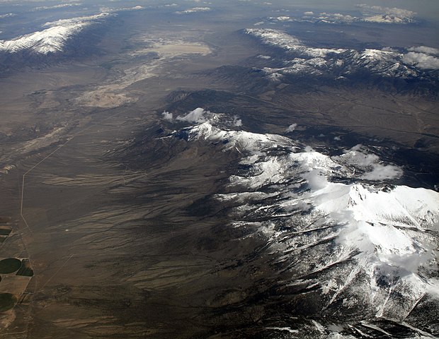
Got that? An endoheric basic is land that doesn’t channel water to the ocean. Most land does. Most land channels rainfall or snow-melt to little creeks, that flow together to become small rivers, which flow together to become one big river which, then, flows to an ocean. An endoheric basin flows water to its own lowest point to create ephemeral lakes or swamps, which may stay till summer dries them away.
The Great Basin is over 209 thousand square miles of land that does not flow water to the ocean. Now, it’s not one giant bowl that channels water from all those square miles into its geographic center somewhere in Nowhere, Nevada. No. Rather, it’s like the surface of a golf ball. There are hundreds of small, independent endoheric basins bunched together across the “Great Basin.”
Once upon a wetter time, there were hundreds of lakes here. In wetter winters, some can come back. However, only a few have survived into permanency. The Great Salt Lake, Utah Lake, Pyramid Lake, Lake Tahoe and Mono Lake are the most renowned examples. There are other small lakes scattered across Western Utah, Nevada and Eastern California. However, most are man-made.
The Great Basin is dry. It averages seven to twelves inches of rain equivalent per year, with more precipitation falling on the mountains than in the valleys or basins in between those mountains. The eastern Great Basin tends to be drier because it’s in the direct “rain shadow” of the Sierras.
Now, building up more necessary vocabulary, also know that a “rain shadow” is an area of land made drier because mountains adjacent to said area block moisture from traveling over it to drop rain and snow. Got it?
Let me give you the most perfect example of a rain shadow on Earth. The west side of California’s Sierras is greener than the east side, because far less Pacific moisture travels over those mountains. Some Sierra peaks are over 14,000′. The mountains prevent rain and snow from falling in Eastern California. Most falls on the west side. Thus, the Mojave’s on the east side.
Some spots along I-40 in California are pure sand. Nothing grows as I’ve said. That can make a boring drive. That can make swamp butt worse. However, this had to happen for the 185-mile stretch from the Colorado River to Barstow.
Ok. Let’s stop at Lupton, California to top off the tank and get something cold and sweet to drink. The gas station there advertised itself as being on old Route 66. Maybe there’d be some quirky souvenir there too. Well, gas was $5 a gallon. There was no way I’d give those Commifornians that amount. So back to the van I went muttering not too softly.
Then, finally, after six hours of driving, I made it to lovely Barstow. By lovely I mean the town doesn’t seem to pay the highest attention to aesthetics, but I’m not saying anything about the people. I’m sure they’re fine. It’s a desert town of roughly 25,000, with the military as its biggest employer. Here, gas was $3.90, which was better than Lupton, but still too high considering the national average then was about $2.68.
I-40 ends here at Barstow. To continue west to Bakersfield, you get on California Highway (CH) 58. CH 58 goes west by northwest towards the Tehachapi Pass – the southernmost pass over the Sierras. On the east side of the pass, are thousands of windmills harnessing strong easterly winds caused by a big temperature differential between the browner east side and the greener west.
Though you don’t reach elevations as high along the Tehachapi like other Sierra passes further north, the temperature did start to cool nicely. Then, the land changes magnificently.
FEATURED IMAGE FROM: upload.wikimedia.org/wikipedia/commons/thumb/2/21/Wheeler_Peak_and_Great_Basin_National_Park.jpg/620px-Wheeler_Peak_and_Great_Basin_National_Park.jpg
