As I begin great work on this blog, I feel the need to address concepts that go over a lot more people’s heads than I formerly thought.
One topic rich with confusion and ignorance is rivers. I’m not trying to be condescending. Not at all. But, there are many basic concepts of rivers I take for granted that to others seem as nebulous as women’s studies. No one ever taught them how to conceive rivers or anything remotely related to geography in their GOVERNMENT schools.
So I write this post. I’ll probably write others making clear basic concepts.
So, a river basin is the area of land drained by the main channel of a river, as well as all the land drained by that river’s tributaries (and their tributaries) which all ultimately flow into that main channel.
By “a river drains the land” is meant “a river collects and carries away the surface water from that land.” That surface water could be from rain, snow, springs, seeps, aquifers or whatever mechanism Nature uses to put water in the channel of a river.
(Of course, there are technical explanations to aquifers, seeps, tributaries and other terms. But, I’d drive myself nuts defining every term. I wonder if I’m nuts now for writing this post. But I see 97.5% of people can’t conceive the full picture of what a river is.)
Now, for illustration, let us just go to the Father of Waters, that is, the Mississippi River of the United States of America. Look at the map below. All the blue lines make up the Mississippi River Basin.
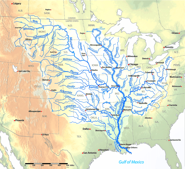
You will observe that the main channel of the Mississippi starts in Northern Minnesota, and flows southward towards the Gulf of Mexico.
You will also observe that other rivers, called tributary rivers, or just tributaries, flow into the Mississippi. On the west side of the Mississippi, you have big rivers like the Red, Arkansas and Missouri. On the east side, you a big river called the Ohio.
You will observe further still that the above-mentioned Mississippi tributaries have tributaries of their own. The Ohio has the Green, Cumberland and Tennessee. The Missouri has the Yellowstone, Platte and Kansas. The Arkansas has the Cimarron and Niobrara. The Red has the Washita.
And, of course, those tributaries of Mississippi tributaries have tributaries of their own. So on and so forth. But you can look at maps to see examples.
So, when I said, “A river basin is the area of land drained by the main channel of a river, as well as all the land drained by tributaries that ultimately flow into that main channel,” this now makes more sense, no?
All land that drains water by way tributaries and tributaries of tributaries, so on and so forth, is part of a river’s basin.
And ain’t that Mississippi Basin huge? I mean, it goes from New Mexico to Alberta to New York to Alabama and then to the Gulf of Mexico south of Louisiana. The Mississippi Basin drains 48% of the landmass of the Lower 48, which makes the flow rate into the Gulf of Mexico at 17,000 cubic meters per second. (Although, that ranks the Mississippi between 8 and 10 compared to discharge volumes of other mighty rivers like the Amazon, Congo, Orinoco or Yangtze. )
Neat, eh?
Regardless, now you should clearly understand what a river basin is.

