I was excited to drive towards Cairo. I was excited to see the Shawnee Hills, the Shawnee Forest, the Little Grand Canyon of Illinois, the Illinois cypress swamps, and the confluence of the Ohio and Mississippi – and I most wanted to see that confluence.
Feeling better to be back at my Tundra – because you know – I headed towards the Mississippi and Illinois. Before too long, East St. Louis surrounded me.
When I meet someone – usually a white someone – who tells me they come from St. Louis, I respond, “Ok, East St. Louis,” as if I misunderstood them. Then I watch their eyes. The reactions are funny, especially within women. That’s because those white people from St. Louis I meet know how dangerous East St. Louis is. There… is a lot of crime there.
The town did look impoverished. As a honky, I wouldn’t have wanted to be there after dark. Call that racist; it’s true.
Then, sho’ nuff, on a sidewalk near a stoplight, at 1:33 on a Tuesday afternoon two African-American gentlemen were enjoying malted alcoholic beverages while blasting hip hop. I was curious to know what accomplishments they were celebrating, as they were quite animated.
However, before I could roll down my windows to initiate such a friendly exchange, the light turned green and I got the hell outta’ there.
Then the cornfields began.
There were a lot of them. This didn’t surprise me. I’ve driven through the flatness of Illinois to behold endless cornfields before. Illinois averages the highest yield of corn per acre in the United States. Iowa produces a bit more corn than Illinois, but only because it has a bit more acres under corn production. Illinois has a higher yield per acre, at least according to Grok.
I think that’s neat to know. For those who are curious, below is the ranking of America’s top 10 corn-growing states, including their acreage under corn cultivation, and the average yield per acre.(1)
| Rank | State | Production (bushels) | Yield (bu/acre) | Harvested acres |
|---|---|---|---|---|
| 1 | Iowa | 2.772 billion | 210 | 13.2 million |
| 2 | Illinois | 2.354 billion | 214 | 11.0 million |
| 3 | Nebraska | 2.027 billion | 194 | 10.45 million |
| 4 | Minnesota | 1.698 billion | 201 | 8.45 million |
| 5 | South Dakota | 1.086 billion | 171 | 6.35 million |
| 6 | Indiana | 1.067 billion | 204 | 5.23 million |
| 7 | Kansas | 942.5 million | 145 | 6.5 million |
| 8 | North Dakota | 711 million | 158 | 4.5 million |
| 9 | Missouri | 677.1 million | 185 | 3.66 million |
| 10 | Wisconsin | 605.4 million | 188 | 3.22 million |
And, whether you’re curious or not, below is a chart of the Top 10 corn-producing nations on Earth, also showing acreage under cultivation, and average yield per acre. You can see America grows the most, and has the highest average yield. Therefore, because Illinois is the highest yielding state in the country with the highest yielding soil on Earth, you can say the best corn-growing soil on Earth is in the Land of Lincoln. (2)
| Rank | Country | Production (million metric tons) | Harvested acres (approx.) | Average yield (bu/acre) |
|---|---|---|---|---|
| 1 | United States | 432 | 91 million | 186 |
| 2 | China | 301 | 112 million | 108 |
| 3 | Brazil | 140–141 | 56–57 million | ~95–98 |
| 4 | Argentina | 63 | ~20 million | ~110–120 |
| 5 | European Union | 57 | ~20 million | ~110–115 |
| 6 | India | ~43–55 | ~28–36 million | ~60 |
| 7 | Ukraine | ~31 | ~11 million | ~110–120 |
| 8 | Mexico | ~25 | ~17 million | ~60 |
| 9 | South Africa | ~17–18 | ~7–8 million | ~85–90 |
| 10 | Canada | ~15 | ~4–5 million | ~150–160 |
Of course, how pertinent statistics like this are to my narrative I don’t know. But the numbers are neat. If you don’t care, you’re probably boring.
Anyways, the further south I went on Illinois 3, which Rand McNally designates as a scenic road, the more the cornfields faded. Trees replaced them. South of a place called Grimsby, “Shawnee National Forest” signs begin to appear. Okay.
The forest was a thick, deciduous forest filled with oaks, hickory, beaches, and certainly elms, ashes and alders. Pines were here and there too. The heat and humidity got worse the further south I went. I thought maybe this part of America could still be pleasant in late spring. Nope.
In addition to the deciduous trees, which comprise a very small fraction of USFS lands in the American West (most USFS lands out West are evergreen), the Shawnee also seemed different for the lack of forest roads you see everywhere in, say, Arizona or Colorado. This is because the Shawnee was not massively logged like the western forests, and thus there is no large number of old logging roads now serving as forest roads, as in all Western States.
The Shawnee Forest, apparently, was formed in quite a different manner compared to, say, the Kaibab Forest in Arizona (which is between Williams and Grand Canyon).
The Kaibab NF, like so many National Forests out West, was formerly unsettled land under federal control. The Arid West was much harder to settle under the strictures of the 1862 Homestead Act – signed into law by Abraham Lincoln. But that Act was written with the good lands of Illinois and Iowa in mind. Arizona is a different place. So is Wyoming. Western lands were too cold or dry or both to grown corn and thus survive upon 160 acres. The homesteading failure rate was much higher out West, and so much of the West remained unsettled. Instead of changing the laws to accommodate for the more arid conditions (as I believe should have been done), federals took enormous areas of land out of the public domain, and reclassified it as National Forest or a smattering of other reserves, all of which could no longer be settled.
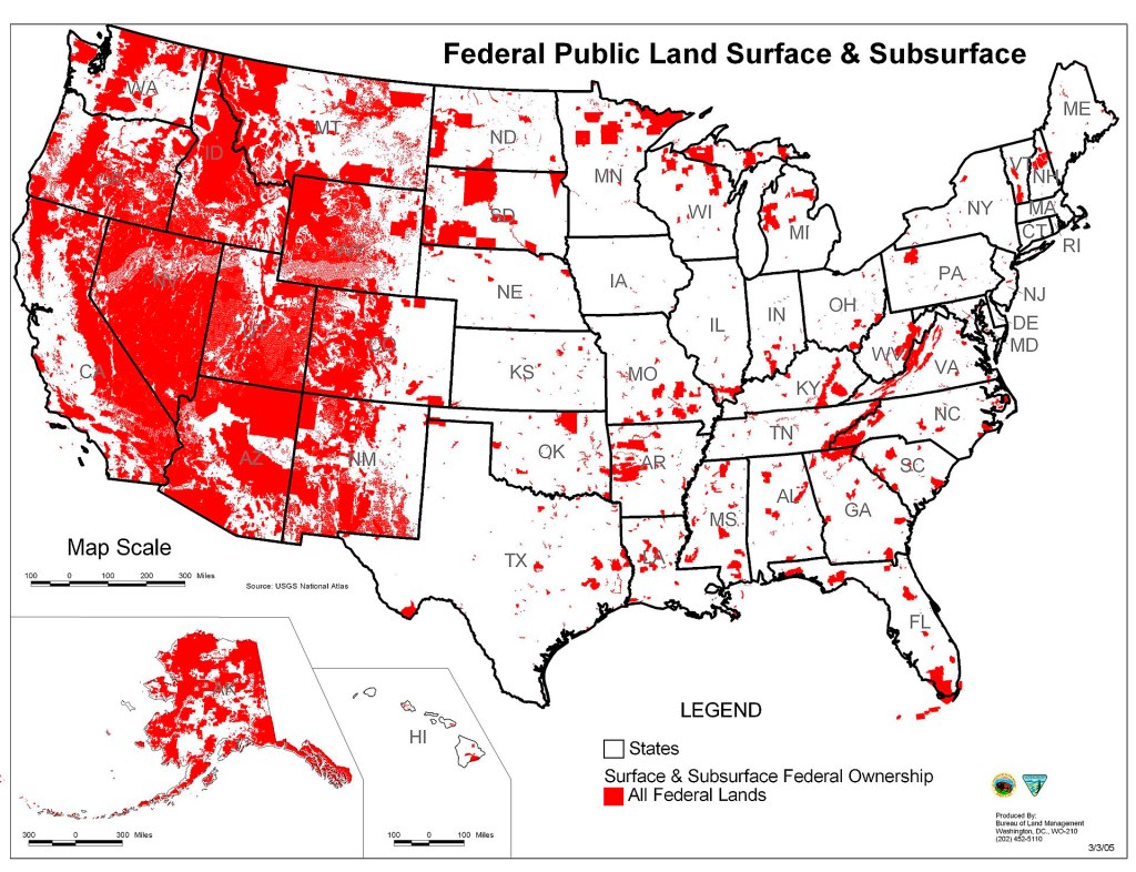
(Indeed, the area of land the federal government controls west of the Great Plains is, again, enormous. I opine such control is unconstitutional, because it is an immoral power grab for land which prevents millions of people from enjoying their God-given right to live upon and depend upon their own soil. It negates a core concept of Liberty. People aren’t so free as landless tenants, and federal villains like Teddy Roosevelt understood this. However, such argumentation is for another post. (Nonetheless, at the bottom of this post, I posted a map showing the area of land under the control of federal agencies across the United States.))
The Shawnee National Forest, on the other hand, was formerly private land. Some was bought by logging companies. Some was settled by farmers. Regardless, according to Grok, the soil had become exhausted by too much farming, grazing and logging. Soil erosion had become a big problem. Consequently, so was paying mortgages and property taxes, especially when that Dust Bowl Drought hit. Thus, in 1933, the federal government began buying up the exhausted and tax-delinquent farms and logging tracts, and grouped them into Illini and Shawnee units of a soon-to-be national forest. Then, the Civilian Conservation Corps began replanting trees within the now-federal lands, and in 1939 the Shawnee National Forest was born.
And though I may be disrespecting the Shawnee People by not devoting more time to them here, the truth is that I am no expert on their history. However, I do know that they were once a powerful tribe who were steadily pushed westward along the Ohio River first by Iroquois and then White Settlement from Ohio into Indiana, Illinois, Missouri and then into the foreign Kansas Plains. Though the Shawnee were once in Southern Illinois, for a mere time, their homeland was the coveted land of what is now the State of Ohio. Now the Shawnee are mostly remembered by a mere National Forest sign, if that.
It’s kind of sad to think about. What people want to be forgotten? None, but what can I do? It does, however, make me want to know more about the history of white settlement moving west from the Atlantic, and how it impacted tribes I know so little about, who were once there.
Regardless, though those Shawnee Hills were hills, they weren’t big. The land was nothing like Arkansas. There were no large vistas. Not very Ozarky.
Then, lo, I saw a sign for the Little Grand Canyon. I was under no pretension that this supposed canyon would be impressive. I knew it was a bit of a joke. But, maybe here it would look like Arkansas??
No. Just more rolling hills. That Ozark upwarping of Earth’s crust wasn’t so impressive in Illinois. But I didn’t expect it to be.
I followed the signs to a parking lot surrounded by tall trees whose canopy covered the parking lot – it might have been virgin Illinois forest. I saw a trailhead sign. You had to walk a trail to see this supposed canyon. Ok. It would be good to walk considering how much driving I’d been doing.
The humidity had to have been 100%. It felt no differently than New Orleans. That humidity is coming from the rivers, and it intrigues me that humidity tantamount to humidity produced by the Gulf of Mexico is produced by the water of the Mississippi and the close-by Ohio. That’s a lot of water. This whole area is such rich farmland, and I imagine many pioneers out this way had figured they’d found paradise.
It didn’t feel like paradise walking the trail. Gnats and mosquitos abounded. I pulled a tick off me (and I’d pull another one off later). But ’twas invigorating. Humidity induced sweat can invigorate, and I was pouring sweat when I made it to the overlook of Illinois’ Grand Canyon, which was just a high bluff above the Big Muddy River flowing west towards the Mississippi. I didn’t bother to get a picture. A minute’s viewing time was enough.
Before too long I was back at my Tundra, and heading towards the Cypress Creek area. I did drive some detours to get views of swamplands, and found one area. It wasn’t exhilarating to see cypress trees in Southern Illinois, and part of me wondered why I made a detour to this area in the first place. I still can’t answer that question. But at least now, dear reader, you know there are cypress swamps north of the Ohio River.
And before too long again I was driving through the rather run-down-lookin’ town of Cairo, Illinois. It certainly never became the seat of a grand inland empire. Yes, it did become important in the days when steamships ruled the commerce of the Mississippi and Ohio Valleys. However, these days didn’t last forever. Railroads across the whole Mississippi Basin made steamships far less important, and therefore prone-to-flooding Cairo less important. Its population has continued to dwindle into the 21 century.
Didn’t see a motel I liked. I crossed the Ohio on US 62, which is just above the confluence, and, indeed, there was a lot of water where the Ohio and Mississippi become one.
But whatever. It was time to stop driving. Remember, I’d woken up at a truck stop north of Kansas City that morning, after little sleep. Now I was in Kentucky. Today was a lot of miles.
So, in some small town south of Paducah, I got a $60 motel with wonderful air-conditioning and slept righteously.
FOOTNOTES:
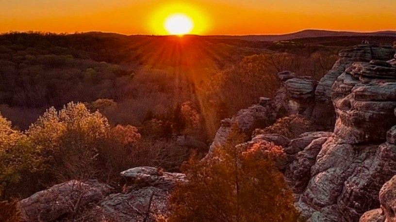
(1) FEATURED IMAGE FROM: www.fs.usda.gov/r09/shawnee
(2) The American corn table was produced from Grok AI by asking it: Can you display a list of the top 10 corn-growing American states, and also show how many bushels per acre each state averages, and the total acreage under cultivation of each state?
(3) The World corn table was produced from Grok AI by asking it: Can you display a list of the top 10 corn-growing countries in the world, and also show how many bushels per acre each country produces, and the total acreage under cultivation of each country?
(4) en.wikipedia.org/wiki/Federal_lands#/media/File:Map_of_all_U.S._Federal_Land.jpg


Charlie,
Lots of information here but interesting. Still enjoying your comments about traveling across the country.
Take care,
Gary
LikeLiked by 1 person