The lowest point in North America’s at Death Valley. As you’ll see below, it’s 282 feet below sea level.
The actual Death Valley is and endoheric basin. You remember what that is? It’s an area of land that doesn’t drain to the sea. It’s a basin where all the rainfall flows unto its own lowest point, like Lake Tahoe and the Great Salt Lake.
The Badwater Basin is, more or less, the lowest point of the whole Death Valley. However, Death Valley is only one of several endoheric basins within the Park. The Panamint Valley to the west of Death Valley is, wow.
Anyway…
You can see “Badwater” on the left third of this Google Map snippet. It’s about 70 miles due west of Las Vegas. Again, here is North America’s lowest point. The only place in this snippet you want to be at in summer is where it’s green, which is up on mountains.
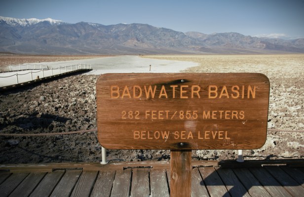
Of course you have to get a photo of the sign. No, the white’s salt, not snow. The wooden boardwalk leads you out onto that salty trail that leads to yon’ distant mountain. Go as far as you want. Don’t die.
The beginning of the boardwalk at the parking lot. Got into a conversation with a Park man cleaning the out houses. The smell of waste didn’t erase the smile from his face. Good on him.
Out on that salt walk a bit. The red-circled sign tells you where sea-level is. I don’t know where exactly the lowest point is, but, it’s gotta’ be close.
Now, the white on the mountain is snow. That’s Telescope Peak. It’s on the west side of the Death Valley. It rises to over 11,000′. Thus, that peak is over two miles above. It doesn’t look that big only because it’s so far away. But, it IS that big.
In the salt flat geometric shapes develop from wind and water. I’m still miles away from Telescope’s base. I’d need a lot more water.
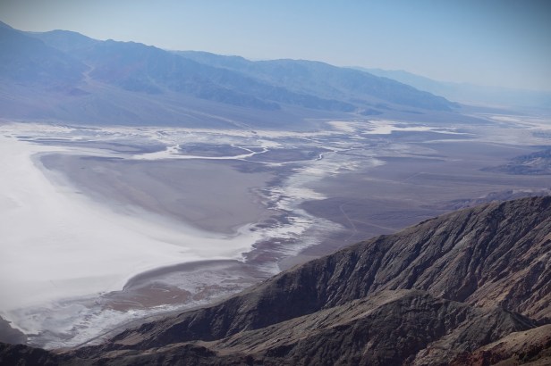
This is the view of the Badwater Basin from Dante’s View, over a mile above, on the east side of Death Valley. I took this photo in 2017. But, why not use it again?