It is my intention to sell photographs I’ve taken over the years at a local artist market.
I believe this can be done. I believe if I put my mind to it, I could make myself into one heckuva photographer. This requires a good camera (which I have bought) and the study of the nuts and bolts of camera operations and development software.
I’ve begun such studies. In spite of proclivities to read books on Ancient Southwest history instead of technical manuals for Adoble Lightroom, the simple fact is that I’ve been putting forth much more deliberate effort in this endeavor compared to years past. Dedicating mornings, evenings and entire days to shooting photos is what I mean when. Often, formerly, I would have rather been lazy.
Only time will only tell the fruits of such efforts. Some have been disappointing. Some have been exhilarating.
Take North Wilson Mountain…
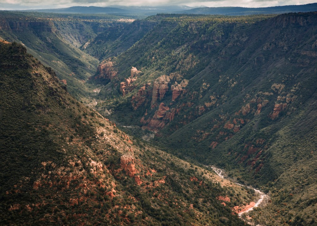
Now, Wilson Mountain is the backdrop to Uptown Sedona. It rises 2,500′ above the tourists, and growing upon its flat top are ponderosa pines that look like matchsticks but are, in fact, 60′ to 70′ tall. I know this because I’ve been up to that Sedona Overlook on top of Wilson – which is actually the southernmost portion of Wilson – many times.
There is also a north side also. I’d only been to that once, in May of 2017. Why I’d not returned I don’t know. C’est la vie. But on Wednesday the 30th of March in the year of our Lord 2022 I was determined to go back.
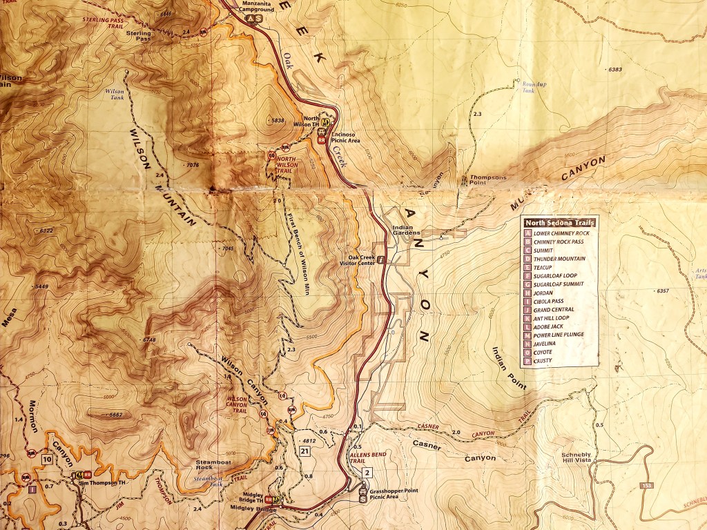
The photo below is a topographic map of the area – a map I love – with the trails imposed upon it. I would start at Midgley Bridge. I’d hike the .8 mile to the wilderness boundary + the 2.3 miles to the First Bench of Wilson Mountain + the 2.4 miles to right near the Wilson Tank to shoot that glorious area on a day after rain in which residual clouds would cast shadows on Creation below to create that contrast between light and dark which enhances the quality of photos. Then I’d walk the 5.5 miles back. 11 total miles would be no problem.
Now, I’m not going to give some Thoreauvian account of my hike. I’ll say it was muddy, and prompted some bad habits to explode from my mouth a time or two, but I made it to the Wilson Bench in good time with minimal sweat where the wet, mountain air went from cold to warm as clouds covered and uncovered solar rays.
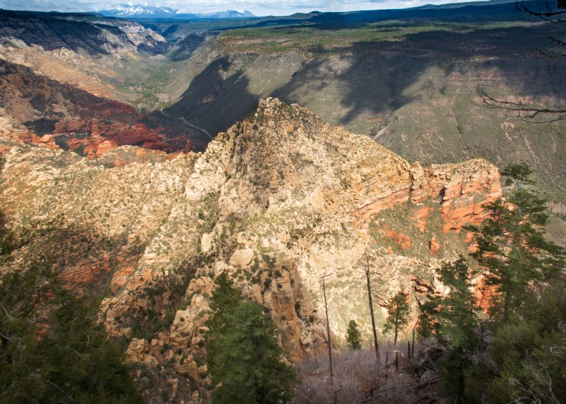
Then, lo, Munds Canyon off to the east on the other side of Oak Creek Canyon – where the nudists hang out. Seriously, at the mouth of Munds Creek, where it flows into Oak Creek, nudists hang out in the summer – and, no, I don’t go there because I don’t want to be around weirdos.
Anyway, it was a perfect landscape for photography. So, I walked the thousand yards eastward off the trail to the mountain edge to capture Munds’ mouth. Spent an hour taking 150 photos as shadow, light and color changed form one minute to the next. Upon Munds and beyond glowed green grass, burnt orange junipers pollinating, and intermittent blue skies above titanic horizons. Here is a world-class majesty to Northern Arizona few see. My photo doesn’t do the area justice.
Then it was time to continue. An hour later I was at the North Wilson overlook. Spent probably 3 hours here along this rim, taking 300 photos.
Most of them are so-so. Even the “best” one I chose for this blog I consider so-so. Wished I had a tripod to minimize blurring, but, I hadn’t had the time to buy one after the last one fell hundreds of feet to its death atop Brins Mesa.

Regardless, wow!
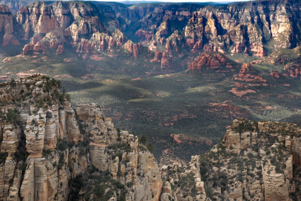
I would say the overlook at North Wilson is one of the prettiest things I’ve ever seen. Here is Northern Arizona’s world-class majesty at a level of emotion equal to Grand Canyon’s, which, of course, is one of the Seven Wonders of the Natural World, and should be. Very few tourists make it here.
To stay a week atop Wilson! To set up camp with 10 gallons of water, and plenty of peanut butter, and a generator to recharge my camera, and… it will never happen. Too much crap to haul. I’d need a mule. A mere couple of days would be hard.
Nonetheless, to see Sedona’s Western Canyons to the west, and the San Francisco Peaks to the north, and Mormon Mountain to the east from which you can almost see Winslow, well, I think there is no better word than “titanic” to summarize the enormity of the landscape from this high point. Here is where vertigo and astonishment blend to create addicting sensations that make me wonder how I could ever leave the Southwest.