Well, this is a concept I didn’t even know existed
A man on a snowy hike right on the Continental Divide within Glacier National Park, near Logan Pass, advised me of this thing called Triple Divide. I’d never heard of it before.
He told me that there is a place within the Park where snow melt flows to three different oceans. He told me from this place that snowmelt can flow to the Pacific or Atlantic or Arctic Oceans. Again, I’d never heard of such a concept before, but it certainly did intrigue me.
So, after buying a DeLorme road atlas for Montana, I peered at the pages dedicated to Glacier Park, and rather quickly found Triple Divide Peak.
In the featured photo above, which is a photograph of page 23 of the atlas, the words surrounded by red indicate the location of Triple Divide Peak.
The blue arrow indicates the flow of water to the St Mary’s river, which is a subtributary of the Nelson River Basin, which flows to Hudson Bay, which some could argue is more a part of the Arctic than Atlantic Ocean.
The green arrow indicates the flow of water to the Milk River, which is a subtributary of the Missouri and thus Mississippi River Basin, which flows to the Gulf of Mexico.
The purple arrow indicates the flow of water to the Flathead River, which is a subtributary of the greater Columbia River Basin whose mouth is at Astoria, Oregon.
From one point the land by rivers can lead you to three different oceans! How neat is that!
(Now the orange line, which is printed on the map, indicates the Continental Divide between the Pacific and Atlantic Basins, which kinda suggests the Hudson Bay is part of the Atlantic. So, I colored in the yellow line to demonstrate the difference between the waters that flow to Hudson Bay and the waters that flow to the Gulf of Mexico.)
Of course, if you have no interest in geography, you couldn’t care less. But to care about rivers – their headwaters, tributaries, mouths and everything in between – is to learn to love geography.
A love of land starts with rivers.
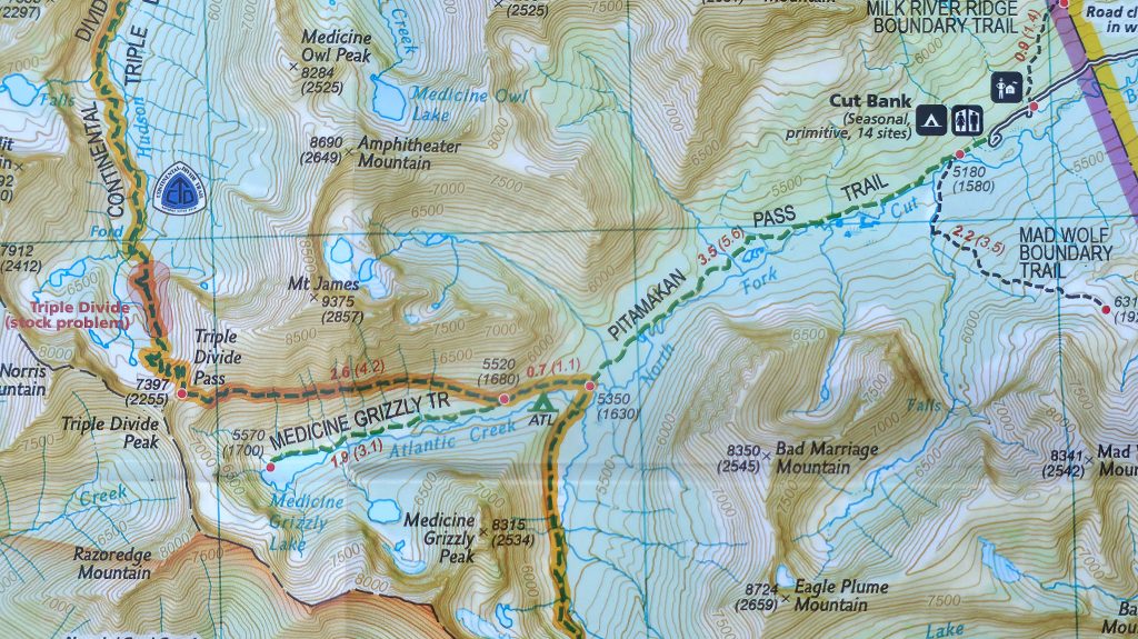
Anyways, according to my National Geographic map of Glacier National Park, there is a trail up to Triple Divide Peak, whose top elevation is 7397′. That’s not too high.
The trail starts at 5180′, so that would be an elevation gain of 2217′, which, again, is not so much. But it’s over 6 miles each way, and I am perfectly entitled to be lazy, and seek only easy photos, be they on top of Triple Divide Peak, or at its base.
A photo of that trail from my National Geographic map is below.
Maybe I’ll go up. Maybe I’ll just drive cIose enough to see it. Don’t know. Praise the good Lord above for the free time to see such beautiful and wondrous places in His Creation!