Here’s a term I didn’t understand until adulthood. No one ever explained it to me.
I’d bet the majority of American adults don’t know what “Continental Divide” means. Maybe that’s you. That’s fine. Today’s you’re lucky day.
The Continental Divide is the divider of waters. The Continental Divide – at least here in the United States of America – is the boundary between streams that flow into the Pacific Ocean and the Atlantic Ocean.
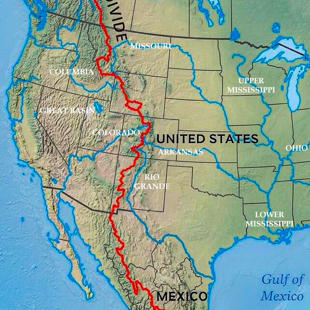
Think about this concept. At some point, as you travel from east to west across America, you will reach a point where streams start to flow westward into the Pacific as opposed to eastward into the Atlantic. That point is the Continental Divide. You can see the Divide as the red line in the map below:
Yes, my map graphics are terrible. I steal from the internet. I couldn’t monetize this post with this map (as if that’s a pressing issue), and I don’t know how to make my own. But if I did…WOW!!!
Anyways, the map shows the Divide running across New Mexico, Colorado, Wyoming and Montana. Yes, the Divide continues southward into Mexico and northward into Canada, as common sense dictates. But we’ll just look at the Divide within the United States.
On the west side of the Divide, you have 2 primary river basins: the Colorado Basin and the Columbia Basin. Follow their paths to the Pacific.
On the east side of the Divide, you also have 2 primary river basins: the Rio Grande Basin and the Mississippi Basin. Yes, the Mississippi itself flows from Minnesota to Louisiana, and doesn’t touch the Rockies, but its Missouri and Arkansas tributaries do originate in the Rockies. Therefore I call it all the Mississippi Basin. as I said in What is a River Basin?
So I hope that interpreting a simple map, as no one had ever done for me, helps.
(And that little red circle in Wyoming is called the Wyoming Divide, which means the streams in that are flow into endorheic basins, or bowls in the land with no outlet to the oceans.)
((And between the Columbia and Colorado Basins west of the Divide there is a gigantic endorheic basin (comprised of many smaller endorheic basins like Lake Tahoe and the Great Salt Lake) called the Great Basin which I wrote about in On the Great Basin…))

